
http://www.ogc.org/blog/3228
Post date:
19 June 2020

"It's an exciting time to be involved in 3D geospatial data. There's more 3D data being captured about the real world than ever before, and it’s being acquired at a higher resolution and at a greater frequency by drones, planes, satellites, and more. Technological advances in sensors and photogrammetry algorithms are leading to a wide array of useful 3D data concerning cities and terrain. Further, new post-processing techniques involving machine learning and artificial intelligence are adding useful semantic information—that is, information about what a 3D object is, rather than just its physical shape—than was previously possible, which has unlocked tremendous value from the captured information.
However, the sheer volume of complex 3D data now available has created challenges concerning access, processing, visualization, and dissemination. Challenges being addressed by a community of collaboration and a diverse, but interoperable, software ecosystem powered by consensus-based open standards.
“These are the challenges we built Cesium to address,” says Patrick Cozzi, Cesium CEO.
Cesium is a complete platform for storing, tiling, visualizing, and analyzing 3D geospatial data. Cesium is also the name of the company that built that platform. Cesium, the company, holds open standards close to its heart, and is responsible for bringing 3D Tiles to OGC for adoption as a Community Standard. 3D Tiles is used across the industry for efficient dissemination of 3D geospatial content, including throughout the Cesium platform.
“Cesium has embraced ‘openness’ because we believe that the fastest way to advance the field is to collaborate across the industry,” says Patrick. “This collaboration is built on interoperability, and interoperability relies on open standards.”
Embracing openness
Through embracing open standards, Cesium has found several benefits—for itself as well as for its customers.
“For Cesium, the benefit of ‘openness’ is that it increases the pace of innovation, the trust within the community, and the ability to create a software ecosystem for the benefit of the whole industry,” says Patrick. “For our customers, ‘openness’ brings access to interoperable and extensible solutions as well as the collective innovation of the community.
“Open standards allow commercial software and open source software to thrive in one interoperable ecosystem, and empowers the customer to choose the best solution to meet their needs.”
Cesium’s commitment to ‘openness’ extends beyond just using standards in their own products, too: Cesium recognises that it is one member of a global community, and works to support the community while also being supported by it.
“By working with open standards consortiums such as OGC, Cesium is able to come together with experts from a diverse set of fields to collaborate and advance standards. By listening to and working with these experts, we know we're serving real use-cases. We focus this energy into building a healthy software ecosystem, not just the specifications themselves.”
In addition to the 3D Tiles Community Standard, Cesium is also a co-creator of the Khronos Group’s glTF open standard for 3D models. Patrick is also a co-chair of the Khronos 3D Formats Working Group.
“There is great collaboration between OGC and Khronos, as the OGC 3D Tiles specification is built upon the Khronos glTF specification,” says Patrick. “This allows the geospatial community to leverage the collective innovation and software ecosystem of the wider 3D community surrounding Khronos, which includes companies like Google, Nvidia, Amazon, and now even Epic Games with its Unreal Engine.”
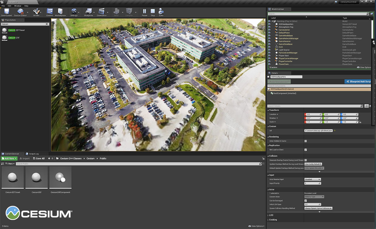
Prototype for Cesium for Unreal Engine showing a high-resolution photogrammetry 3D tileset of AGI headquarters, where Cesium originated.
New Opportunities
With a strong embrace of ‘openness’ among a thriving, enthusiastic, collaborational community of experts, the challenge of working with today’s growing amount of 3D geospatial data presents some amazing opportunities.
“3D geospatial is crosscutting many markets—from modelling & simulation for use in training and operations for the Department of Defense, to smart construction, real estate, oil & gas, smart cities, and more. This is a tremendous opportunity to bring real-world 3D, in the form of digital twins, to a wide array of markets.”
One such example of a digital twin comes from the earthworks industry.
“There has been incredible progress in smart construction, where the combination of drones, rovers, and sensors on bulldozers, excavators, and other machinery, are creating near real-time digital twins of construction sites,” says Patrick. “This information is fused together to visualize the operation of the construction site and understand its progress over time. This technology answers questions like how much dirt is moving, if an organization is on schedule, or how close they are to a target design model.”
Outside the earthworks and construction industries, training and planning in an environment that is as close to the real thing as possible provides operational and competitive advantages for the military. The ability to take data captured by satellites and drones and create high resolution, accurate, digital twins, models & simulations of the physical world is an important emerging trend.
Indeed, the current global “NewSpace” movement has and will provide huge opportunities for the geospatial community, including Cesium. In fact, Patrick recently presented on analytics & visualization as part of a virtual OGC NewSpace workshop (recording available in the link).
“Cesium was originally developed for aerospace, so New Space is dear to our hearts and core to our mission,” says Patrick. “It’s such an exciting time in this domain. There's more data being collected by satellite than ever before. There’s also an increase in coverage, as satellites can go over regions that are denied or hard to access. They also refresh the data quite frequently, so we’re seeing the same areas being collected over and over again.”
Adding a temporal dimension to already complex 3D data is another challenging opportunity that Cesium and the geospatial and 3D communities continue to address.
“We're really interested in the temporal aspect of 3D Tiles and the change in an environment over time, whether it's tracking dirt movement for earthworks, or tracking a city's transformation over time. It’s incredibly valuable to be able to understand those changes and review the history of them.”
Geospatial data has changed significantly over the years, growing in complexity, dimensionality, detail, and frequency. But with each technological advance, the geospatial and related communities have risen to the challenge of finding interoperable ways to access, process, visualize, and disseminate this information, allowing collaboration across diverse communities, viewpoints, and softwares. By embracing open, consensus-based standards, Cesium and its customers are poised to take advantage of this current trove of 3D data, now and into the future."
No comments:
Post a Comment